Hurricane Fault
The Hurricane Fault is one of the largest, longest, and most active faults of Southern Utah and Northern Arizona. Its nearest rival is the famous San Andreas Fault in California, about 200 miles to the southwest. Although the Hurricane Fault is not the boundary of two tectonic plates on the Earth’s surface (the North American and Pacific plates) like the San Andreas, it is the boundary between three of the significant ecosystems of the American Southwest.

The Hurricane Fault is also referred to as the Hurricane Cliffs, simply because the fault created a sizable escarpment along its northern segment. The escarpment is what’s also commonly referred to as a fault scarp.
The towering Hurricane Cliffs (Hurricane Fault) near Anderson Junction (I-15 and Utah 17)

Hurricane Fault, near the town of its namesake, the town of Hurricane, Utah

The Fault’s Mark on the Landscape
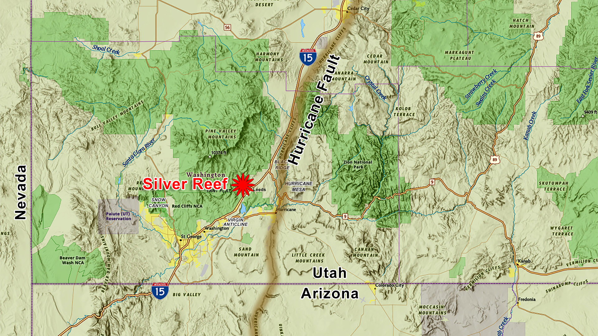
Unlike the San Andreas, the Hurricane Fault is easy to find as it left a big mark on the Earth’s surface. From the south, it begins near Peach Springs, Arizona, just south of where Route 66 crosses it. To the north, it ends near the town of Paragonah, Utah. For roughly half its length, heavily traveled Interstate 15 parallels the fault’s trace — not by coincidence, but because the fault created a natural corridor that made road construction far easier.
South of the Colorado River, the fault and the river follows the same course for several miles, creating a small portion of the larger Grand Canyon. As the river heads west, the fault continues its southern course creating Peach Springs Canyon that contains the only road where vehicles can drive down into the Grand Canyon all the way to the river.
Geologic Overview
The Hurricane Fault is classified as a normal fault. This means that the land on one side of the fault is dropping, while the land on the other side is rising. It’s the abrupt higher edge on the one side of the fault that is called a fault scarp. In comparison, the San Andreas Fault is a “strike-slip fault”. This means that the land on each side of the fault is sliding horizontally past the other in opposite directions.


With the Hurricane Fault, the Colorado Plateau side, the east side, has risen significantly. According to geologists, the Colorado Plateau has risen about a mile in less than 100 million years. Evidence of this can be seen from Silver Reef by seeing certain geologic formations, such as Navajo Sandstone formation, sitting on one elevation near Babylon in the foreground and on the west side of the fault, where the same formation is sitting far in the background (inside Zion National Park) on the east side of the fault about 5,000 feet higher (5,280 feet equal a mile).
The Hurricane Cliffs, the fault scarp, formed from repeated earthquakes over a span of 850,000 years, one earthquake at a time. With every earthquake, the western side of the fault dropped while the eastern side rose, around 5 to 10 feet per earthquake. The fault remains active today and can produce damaging earthquakes up to about magnitude 7.0. It was responsible for the 1992 magnitude 5.8 St. George earthquake, although that particular event occurred on the nearby, parallel Washington Fault.
Through the Washington County area — including Silver Reef, St. George, and Hurricane — there has been no recent movement on the Hurricane Fault itself. If the fault had slipped within the past thousand years, there would be a small waterfall or cascade where the Virgin River and other streams cross the fault trace. The absence of these features indicates that this segment has been quiet for some time.

Hurricane Fault near Silver Reef – hover mouse over pulsating dots to reveal places

Black Ridge & Black Ledge
One very interesting portion of the Hurricane Fault is Black Ledge, which is part of the larger Black Ridge, also known as the Kanarra Fold. This is the portion of the Hurricane Cliffs between the towns of Toquerville and Pintura. Black Ridge is named after the black basalt (lava) flow that caps the top of the cliffs. This ledge holds important clues to the origin of this towering escarpment.
Specifically, Black Ledge, is the thin cap of basalt seen above Anderson Junction (intersection of I-15 and SR 17 or exit 27). This can be seen by looking northeast from the Wells Fargo building in Silver Reef. A group of radio tours sit on top of Black Ledge.
Black Ledge is part of the Pintura lava flow, which erupted from a cinder cone or fissure just near Pintura, five miles north of Anderson Junction. Like all lava flows acting similar to liquid, it flowed downhill, following the Ash Creek drainage all the way to the Virgin River in Hurricane, a distance of 12 miles.
Geologists dated the lava flow using sophisticated radiometric techniques that measure the natural radioactive decay of trace amounts of uranium in the rock, determining that it erupted about 850,000 years ago. At the time of the eruption, the large escarpment we see today did not yet exist; instead, easily eroded strata — primarily the Triassic‑aged Moenkopi and Chinle Formations — covered the area before the east side of the fault began to rise. As a result, the lava was able to flow eastward across the fault as well as southward down towards the Virgin River.
During the 850,000 years after the eruption, reoccurring earthquakes on the Hurricane Fault have displaced the lava flow about 1,200 feet vertically, leaving remnants perched high on the cliffs. Knowing how much of the rock was offset by the faulting (1,200 feet), and knowing the age of the flow (850,000 years old), it is a simple matter to calculate a long-term average rate of displacement on the fault of nearly two feet per thousand years. Two feet per thousand years may not seem like much, but it adds up given enough time. This may mean that earthquakes along this portion of the fault only occurred every one to two thousand years. In comparison, earthquakes along the San Andreas Fault, depending on the location, occurs every one to three hundred years.
The Grand Canyon Connection
The escarpment above Anderson Junction consists of yellowish-brown sandstone and gray limestone and reveals a much older part of Utah’s geological history as compared to the geology around Zion National Park. The sedimentary layers exposed and visible on the side of the escarpment contain the oldest rocks exposed in southwest Utah. The sandstone is a former subtropical beach deposit that was flooded and ultimately buried by fossiliferous limestone as an ancient sea floor that migrated across the continent nearly 300 million years ago.
We know that the sandstone and limestone were deposited in a warm, subtropical ocean because of the fossils and sedimentary structures they contain. The limestone contains fossil invertebrates such as brachiopods, crinoids, corals, bryozoans, and sponges that once lived in coral reef communities similar to those of the modern Bahamas. This limestone belongs to what geologists call the Toroweap and Kaibab Formations. These same formations appear in the Grand Canyon near the top of the north and south rims, as pointed out below.

Use your mouse to click and hold over the vertical bar, then slide back and forth to reveal the geographic formations in the same stratigraphic order between the Hurricane Fault at Anderson Junction and the North Rim of the Grand Canyon just below Maricopa Point.


The following are the geologic formations at the same stratigraphic levels at both locations.
(A) – Kaibab Limestone Formation
(B) – Toroweap Formation
(C) – Coconino Sandstone Formation / Queantoweap Sandstone
(D) – Hermit Formation / Pakoon Dolomite
The same four geologic formations exposed and visible below Black Ledge are also exposed in the Virgin Gorge, 35 miles to the southwest. Driving I-15 south of St. George through Arizona is a great way to see similar geologic layers and formations that also exist in the top half of the Grand Canyon.
Pintura & Kanara Anticline
If you look carefully, you can see that the layers of sandstone and limestone in the escarpment are tilted to the east. They are part of a long fold geologists call an anticline—an upwarp in the rocks that formed about 100 million years ago during a mountain-building episode called the Sevier orogeny. This is the Kanarra anticline (not to be confused with the Virgin anticline), which extends nearly 40 miles from Toquerville on the south to Cedar City on the north.
The Sevier orogeny was a major mountain‑building episode that affected a broad region from Mexico to Canada, passing directly through central Utah. An orogeny is a tectonic process in which sections of the Earth’s crust are compressed, folded, and deformed—typically by lateral (horizontal) forces—resulting in the uplift and formation of mountain ranges.
The only part of the fold exposed today is its east limb—the fold’s crest and its west limb are down-dropped to the west by the Hurricane Fault where they are hidden (buried) by younger deposits. Still, the east limb preserves amazing evidence of that mountain building event. Compressional deformation was so intense that in places the east limb of the fold is overturned and strata are cut by faults that helped to accommodate tight folding in the core of the anticline.
Interestingly, the Hurricane Fault here has reactivated a part of the pre-existing fault that formed the Kanarra anticline. The Kanarra anticline formed above what geologists call a blind thrust fault, where rocks were incrementally shoved eastward, one earthquake at a time over the span of several million years, forming a fold, much like the folds of an area rug that crumples in front of a sliding child.
When the Hurricane Fault was forming about 15 to 20 million years ago, it took advantage of this pre-existing break in the rocks. Just like flowing water creating canyons by following the path of least resistance, faults form by cracking through rock layers with the least resistance. The Hurricane Fault is the largest of several large faults that broke apart the west margin of the Colorado Plateau. These faults formed beginning and are a direct result of the birth of the San Andreas fault system at the western margin of North America. Movement of the San Andreas fault ultimately caused extension throughout the America Southwest. The Hurricane and its sister faults reflect the eastward edge of that extensional deformation.
Epilog
Having such a significant geologic feature—the Hurricane Fault—so close to Silver Reef makes the surrounding landscape even more dramatic and rewarding to explore. Now that you’re armed with a deeper understanding of the area’s geologic story, I hope you’ll venture out and see how the pieces of this landscape puzzle fit together. With this new perspective, the cliffs, canyons, and valleys around Silver Reef take on an entirely new meaning.