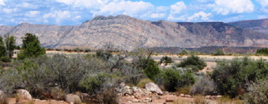
The Hurricane Cliffs dominate the view northeast from the Silver Reef Wells Fargo building. Black Ledge, named for the thin black lava flow that caps the southern end of the cliffs, holds important clues to the origin of this towering escarpment.
At the base of Black Ledge is the largest earthquake fault in southern Utah — the Hurricane fault.
The Hurricane Cliffs are in essence a fault scarp of the Hurricane fault. The scarp formed from repeated earthquakes over the span of 850,000 years, one earthquake at a time, each earthquake dropping the western side of the fault down against the eastern side, perhaps by 5 or 10 feet at a time. The fault is still active and is capable of generating damaging earthquakes of about magnitude 7.0. The fault was responsible for the 1992 magnitude 5.8 St. George earthquake.
The cliffs themselves are yellowish-brown sandstone and gray limestone and reveal a much older part of Utah’s geologic history. These are among the oldest rocks exposed in southwest Utah. The sandstone is a former subtropical beach deposit that was flooded and ultimately buried by fossiliferous limestone as an ancient ocean migrated across the continent nearly 300 million years ago.
We know that the sandstone and limestone were deposited in a warm, subtropical ocean because of the fossils and sedimentary structures they contain. The limestone contains fossil invertebrates such as brachiopods, crinoids, corals, bryozoans, and sponges that once lived in coral reef communities similar to those of the modern Bahamas. This limestone belongs to what geologists call the Toroweap and Kaibab Formations, the same rock formations that form the rim of the Grand Canyon.
If you look carefully, you can see that the layers of sandstone and limestone are tilted to the east. They are part of a long fold geologists call an anticline—an upwarp in the rocks that formed about 100 million years ago during a mountain-building episode called the Sevier orogeny. This is the Kanarra anticline, which extends nearly 40 miles from Toquerville on the south to Cedar City on the north. The only part of the fold exposed today is its east limb—the fold’s crest and its west limb are down-dropped to the west by the Hurricane fault where they are concealed by younger deposits. Still, the east limb preserves amazing evidence of that mountain building event. Compressional deformation was so intense that in places the east limb of the fold is overturned and strata are cut by faults that helped to accommodate tight folding in the core of the anticline.
Interestingly, here the Hurricane fault is a reactivated part of the pre-existing fault that formed the Kanarra anticline. The Kanarra anticline formed above what geologists call a blind thrust fault, where rocks were incrementally shoved eastward, one earthquake at a time over the span of several million years, forming a fold, much like the folds of an area rug that crumples in front of a sliding child.
The Hurricane fault took advantage of this pre-existing break in the rocks. It is the largest of several large faults that break apart the west margin of the Colorado Plateau. These faults formed beginning about 15 to 20 million years ago and are a direct result of the birth of the San Andreas fault system at the western margin of North America. Movement of the San Andreas fault ultimately caused extension throughout southwestern North America. The Hurricane and its sister faults reflect the eastward edge of that extensional deformation.
How active is the Hurricane fault? We can look to those black rocks for an answer. That thin layer of black rock perched high atop the south end of the Hurricane Cliffs is part of the Pintura lava flow, which erupted from a cinder cone just northwest of Pintura. Like modern lava flows it flowed downhill, following ancestral Ash Creek all the way to the Virgin River, a distance of 12 miles.
Geologists dated the lava flow using a sophisticated radiometric dating technique that measures the natural radioactive decay of trace amounts of uranium in the rock and found that it erupted 850,000 years ago. At the time the lava flow erupted, there were no large cliffs like we see today because easily erodible Triassic age strata were then exposed on the upthrown side of the fault. The lava was able to flow eastward across the fault as well as southward down the ancestral Ash Creek drainage.
In the intervening 850,000 years ago, recurrent earthquakes on the Hurricane fault have displaced the lava flow about 1200 feet down to the west, leaving remnants perched high on the cliffs. Knowing how much the rocks are offset by faulting (1200 feet) and knowing the age of the flow (850,000 years old), it is a simple matter to calculate a long-term average rate of displacement on the fault of nearly two feet per thousand years. Two feet per thousand years may not seem like much, but it adds up given enough time. A rugged 4-wheel drive road leads to communication facilities atop Black Ledge, where one can stand on a remnant of the Pintura lava flow and look west and north to parts of the flow on the opposite side of the fault over a thousand feet below.


